How to Scout Public Land: Lessons from Hunters Who Live on Pennsylvania's State Game Areas
I've got a group of guys from Pennsylvania who treat scouting like a second job. They don't have leases. They don't have family farms. They hunt State Game Land and state forests alongside 900,000 other licensed hunters in a state where rifle opener shuts down school districts. And they consistently put deer on the ground, which makes people ask how they do it on public land.
The answer isn't luck. It's a scouting system they've refined over years of hunting some of the most pressured public ground in the eastern U.S. I've watched them work, hunted with them, and picked their process apart enough to know it translates to any public land in any state. But the examples here come straight from the ridges, laurel thickets, and hollows of Pennsylvania's game lands, because that's where these guys prove it works every fall.
The Core Concept: Scout in Layers, Not All at Once
The system breaks scouting into three phases, each one narrowing the focus so you're not wasting time walking ground that won't produce.
Phase 1: E-scouting. Done from home using mapping apps, satellite imagery, and topo data. The goal is to eliminate 90 percent of a property and zero in on 8 to 10 spots worth walking to.
Phase 2: Boots on the ground. Walk those 8 to 10 spots during the off-season and verify what the map showed you. Sign, cover density, access difficulty, and the stuff satellite images can't tell you. Cut the list to 3 or 4.
Phase 3: Hunt-week verification. A quick, low-impact check 2 to 5 days before you hunt. Fresh sign, wind options, and entry routes. You're not scouting anymore. You're confirming.
One of the guys put it simply: "I want to walk 200 acres with purpose, not 10,000 acres hoping to get lucky." That's the whole idea. Each phase filters out bad spots before you invest real boot leather in them.
Phase 1: E-Scouting from Home
Start with a mapping app. onX Hunt is the standard for public land because the boundary layers show you exactly where State Game Lands and state forest boundaries run. In Pennsylvania, game lands butt up against private land with minimal signage in a lot of places, and the boundary lines on the app keep you legal. Load your target property and toggle between satellite and topo views. You're looking for five things:
Saddles and passes on ridgelines. Pennsylvania's parallel Appalachian ridges create natural saddles where deer cross from one drainage to another. These show up clearly on topo maps as contour lines pinching together along the ridge. On SGL 76 in Clinton County, the guys found three saddles along a two-mile stretch of ridge that all funneled deer movement between a bedding slope and a feeding flat below.
Laurel thickets on north-facing slopes. On satellite imagery, mountain laurel appears as dark, dense patches that retain their green into winter. In PA's big woods country, these thickets are where pressured bucks bed because no one wants to fight through them. Flag the ones that sit on north-facing slopes with hardwood feeding areas nearby.
Benches on steep terrain. A bench is a flat or gently sloped shelf partway up a mountain. Deer use benches as travel corridors and bedding areas because walking a bench burns less energy than climbing the full ridge. They show up on topo maps as a wider spacing between contour lines on an otherwise steep slope.
Thick cover far from parking areas. Pull up the game lands map and note every parking pull-off and gated road. Then look for terrain features more than a mile from any of those access points. On SGL 12 in Schuylkill County, the reclaimed strip mine land on the far side of a gated road held deer and bears that the roadside hunters never reached.
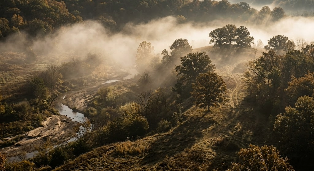
Creek confluences and drainage heads. Where two small drainages merge, the terrain often creates a natural pinch point. Water, cover, and topography all concentrate deer movement at these spots. The PA big woods are full of unnamed feeder creeks that create funnels the map makes obvious, but the ground makes it hard to see through the timber.
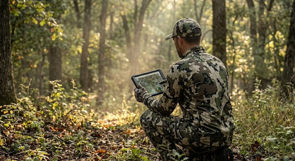
Drop pins on every spot that hits. Don't edit yourself yet. You want 8 to 10 candidate locations. For a deeper digital read on terrain features, tools like Hunting Scout pull real geospatial data from USGS and NOAA and build an interactive scouting report for any piece of ground, public or private. The guys started experimenting with for me, running reports on their game lands tracts last year, and found funnels they'd walked past for seasons without noticing. I spent years learning to read contour lines and predict thermals on different terrain. Hunting Scout does that work for you, faster and more accurately than I can do it from a paper map, and shows you exactly what it means for every stand you've tagged.
Phase 2: Boots on the Ground
In Pennsylvania, the best time for this is late February through April. Snow is melting, leaves are down, and you can see terrain features and last fall's sign that summer growth buries. You're also far enough from hunting season that any disturbance you cause is forgotten by October.
Walk each pinned location. At each one, check four things:
Sign density. Rubs, scrapes, trails, beds, droppings, tracks. In PA's big woods, rub lines along ridge benches are the clearest indicator that bucks use a travel corridor consistently. Old rubs from the previous November still tell you something valuable in March. They tell you deer used this spot when it mattered. One of the guys marks every rub line he finds on his mapping app and looks for patterns across multiple seasons. The rub lines that show up in the same spots year after year are the ones worth hunting.
Cover quality at eye level. Satellite imagery shows you what's green and dark, but it can't tell you how thick the understory is at eye level. Pennsylvania laurel thickets that look impenetrable from above sometimes have openings at ground level where deer bed, with good sightlines downhill. Walk into the cover and see for yourself. Park-like timber with no understory isn't going to hold bedding deer after the first day of rifle season, no matter how good the topo looks.
Access difficulty. This matters more in PA than almost any other state because of the sheer hunter density during rifle season. How do you get to the spot without walking through bedding, crossing an open ridge, or making noise on a creek crossing? Can you approach from downwind in the dark? One of the guys maps his approach routes as carefully as he maps the stand locations. A great spot with a terrible entry is one you'll blow out on the first morning.
Pressure evidence. Look for other hunters' sign. Old stand straps on trees. Climbing stick scars. Flagging tape. Boot prints. In PA, every serious whitetail hunter on a State Game Lands tract gravitates toward the same obvious saddles and oak flats. If a spot has three sets of old sticks on trees within 100 yards of each other, it's been found. That doesn't mean you can't hunt it, but the deer there are educated.
After walking all your pins, you should have 3 to 4 spots you trust. For each one, note the best wind direction, the entry route you'd use in the dark, and exactly where you'd set up.
Phase 3: Hunt-Week Verification
Two to five days before your hunt, make a quick trip. Don't go deep. Don't walk through bedding. Stay on the edges.
You're looking for fresh scrapes opened up along trails, new rubs on trees that were clean two months ago, fresh tracks in soft dirt at creek crossings, and any change in cover since your last visit. In PA, this is also when you check whether a logging operation has started on or near your spot. State forests and game lands both run active timber harvests, and a fresh cut can completely change deer patterns overnight, sometimes for the better if the cut is recent enough that browse is already coming in.
Check the forecast. Match each spot to the wind. If you've got a northwest wind and your best saddle plays a south wind, hunt a different location. Never force a spot on a bad wind just because you found the most sign there.
A Concrete Scenario: How This Played Out on a State Game Lands Tract
One of the guys hunts a game lands tract in the north-central mountains, Potter County, deep, big woods. The property is about 8,000 acres of mixed hardwood ridges, hemlock ravines, and laurel-choked north-facing slopes. Access comes from two parking areas on a township road along the south boundary, and most hunters walk straight up the ridge from those lots and sit within a half mile of the road.
Hunt Scout showed a bench running east to west along the north face of the main ridge, about two-thirds of the way up. Below the bench, a laurel thicket covered the slope down to a small creek. Above the bench, open hardwood climbed to the ridgetop. A saddle crossed the ridge about 1.4 miles from the nearest parking area. On the satellite, the laurel was dense and dark. The bench showed as a band of slightly thinner canopy between the laurel below and the hardwood above.
March scouting confirmed everything. A heavy trail ran the length of the bench with rubs on both sides. Three beds in the laurel just below the bench, all on the downhill edge where deer could see below them and bail into the thicket behind them. A scrape line at the east end of the bench where it narrowed toward the saddle. No hunter sign. The 1.4-mile walk, the creek crossing, and the steep climb to the bench were keeping everybody out.
On a late-October archery hunt with a southwest wind, he parked at the east lot, crossed the creek 400 yards east of the bedding (downwind), and climbed the ridge on the east face rather than coming up the south slope where the bedded deer would see or smell him. He set up in a tree at the east end of the bench, where the scrape line converged with the bench trail near the saddle. The southwest wind carried his scent off the ridge to the north, away from both the bedding below and the trail along the bench.
A nice buck walked the bench trail at 7:40 AM, hit the scrape line, and stopped broadside at 22 yards. That spot has produced for three seasons since, and the only reason it still works is that the access keeps everyone else from finding it.
When to Scout: Season, Weather, and Terrain
E-scouting works any time. Do it in January while you're dreaming about next season. Do it in August when you're itching to get back in the woods. The more time you spend reading PA topo maps, the faster you get at spotting benches, saddles, and funnels.
Boots-on-the-ground scouting is best from late February through April. Pennsylvania's snow melt reveals trails, beds, rub lines, and scrape craters that summer growth erases. Leaves are down, so you can see terrain features and sight lines that are invisible in October.
This system works on every type of PA terrain. The big woods ridges of north-central PA, the ag-edge woodlots of Greene County, the reclaimed strip mine land in the coal region, the Pocono plateau, the rolling hardwood of the Alleghenies. The terrain features you're targeting change (saddles on ridges in Potter County vs. timber fingers between crop fields in Washington County), but the three-phase process stays the same.
Tools and Gear You Need
Mapping app.onX Hunt for State Game Lands and state forest boundaries, satellite/topo toggle, and offline maps. In PA, game lands boundary paint blazes can be hard to spot in thick timber. The digital line keeps you legal.
Binoculars. Vortex Diamondback HD 10x42 for reading terrain and sign from a distance during scouting trips. You want to glass a bench or a scrape line without walking through the middle of everything.
Rubber boots. LaCrosse Alphaburly Pro to minimize your scent footprint. PA scouting means creek crossings and wet laurel thickets on almost every trip.
Notebook or phone notes. Record wind direction, sign type and quality, access notes, and GPS coordinates for every spot. You'll forget the details if you don't write them down. One of the guys keeps a running notes file per game, going back five years. That data compounds.
Trail cameras (optional and risky on PA public land). Trail cameras on Pennsylvania State Game Lands disappear. Theft is common enough that the guys only run cellular models like the Muddy Matrix 2.0, so they don't have to walk into them. And they accept the reality that a camera on public ground is a temporary asset, not a permanent one.
The Three Biggest Mistakes When Scouting Public Land
Scouting the same ground that everyone else scouts
In Pennsylvania, the obvious saddles and oak flats within a quarter mile of every parking area get found by every hunter who walks in from that lot. The sign you're reading near the road is from deer that have already adjusted to human traffic. Push past the mile mark. Cross the creek. Climb the steep side of the ridge. In PA's big woods, the best scouting starts where the easy walking ends.
Scouting too close to hunting season
Walking through a State Game Lands tract the weekend before rifle opener, crashing through laurel thickets and bumping deer out of bedding, is not scouting. It's teaching deer exactly where you'll be. The guys do their heavy walking in late February and March. By the time archery opens in October, they already know where they're going. The fall visits are surgical. Get in, check fresh sign on the periphery, get out. Five minutes, not five hours.
Ignoring how other hunters access the property
Most PA public land hunters park at the pull-off, walk the easiest path uphill, and sit within half a mile. If you don't map that pressure pattern, you're competing with every other hunter on the property for the same deer. The guys map parking areas and trails the way they map deer sign. Once you see where the pressure concentrates, you see where the gaps are. And the gaps are where public land hunting gets good.
Advanced Application: Turning Pressure Into an Advantage
After scouting a PA game lands tract for two or three seasons, you start to understand how hunter pressure moves deer. On rifle opener, the wave of orange coats pushes deer off the easy-access ridges and into the thick, steep, ugly terrain that nobody wants to hunt. By day three, every deer that survived the first push is bedded in laurel, cedar swamp, or a steep-sided ravine far from any road.
One of the guys deliberately scouts for these pressure refuges rather than the spots that hold deer in October. He's not looking for where deer live during archery season. He's looking for where they go after 500,000 hunters hit the woods on the Monday after Thanksgiving. He scouts the nastiest, steepest, most laurel-choked terrain on the property, the stuff other hunters look at and keep walking. Then he hunts those spots on day three, four, and five of rifle season, when the rest of the woods is empty and the deer are stacked in the only cover that hasn't been walked through.
That's advanced scouting. You're not just reading deer sign. You're reading hunter behavior and deer response to that behavior, then positioning yourself where the math works in your favor.
For property-level terrain analysis showing where bedding, travel corridors, and pressure refuges intersect, Hunting Scout builds interactive reports from real USGS and NOAA data. The guys run reports on their public-lands tracts before the off-season scouting trips and use funnel detection to find spots they'd otherwise miss in the dense PA timber. For larger properties or tracts adjacent to public ground, a drone-based assessment from ScoutFlight Hunting Assessments gives you terrain and cover data that takes years of boot scouting to build.
Frequently Asked Questions
How far in advance should you scout public land?
Start e-scouting as early as you want. The best time for boots-on-the-ground scouting in Pennsylvania is late February through April, when snow is melting, leaves are down, and deer sign from the previous fall is still visible. This gives you a six-month gap between your heaviest disturbance and archery opener, long enough for deer to forget you were there.
How do you scout public land without bumping deer?
Wear rubber boots to minimize scent. Scout during midday when deer are bedded and least active. Stay on the edges of bedding cover, especially PA laurel thickets, rather than walking through the middle. Use binoculars to read sign from a distance. And do your heaviest scouting during the off-season, not the week before your hunt.
What should you look for when scouting public land for deer in Pennsylvania?
Focus on terrain features that concentrate movement: saddles on ridgelines, benches on steep slopes, pinch points where drainages merge, and transitions between habitat types like laurel and hardwood. Then verify with sign on the ground. The best spots in PA combine strong terrain features with heavy sign AND access that's difficult enough to keep the rifle-season crowd away.
Can you scout PA State Game Lands during hunting season?
Yes, and you should, but keep it light. Don't walk through your hunting spots during the season. Use what you learn while hunting to adjust. If deer are consistently moving through a funnel 200 yards from your setup, make a mental note and shift for your next sit. Mid-season scouting in PA is observation from the stand, not exploration on foot. Save the walking for February.