How to Read a Saddle Without an App
The battery dies on you a mile in. Maybe the cell signal flatlines the moment you step into the timber. Or you're hunting a pressured public chunk where you've decided to leave the phone in airplane mode so you can actually pay attention to the country in front of you. Whatever the reason, when the app goes dark, you'd better know how to read terrain with a paper map and your eyes.
A saddle is one of the most productive terrain features in deer country, and learning to spot one without help from a screen is a skill every public land hunter should own. This is how to read a saddle without an app, evaluate whether it's worth hunting, and set up on it once you've confirmed it.
What a saddle actually is
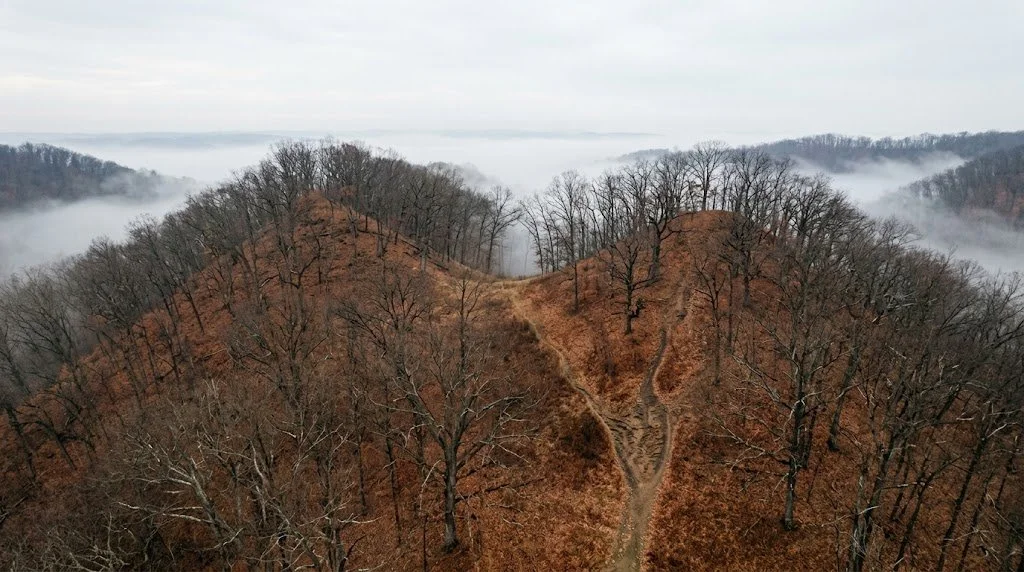
Picture a ridge running across the landscape with two high points along its spine. Between those two high points sits a lower section, like the dip in a horse's back where a rider sits. That dip is a saddle.
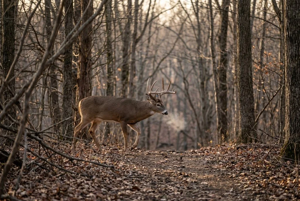
Deer, elk, bears, turkeys, coyotes. Every animal that moves through hill country takes the path of least resistance. A saddle cuts the climb in half compared to going over a peak, and it concentrates animals from both sides of the ridge into one narrow crossing point. That's why saddles show up in just about every serious whitetail strategy article you'll read, and why a well-placed saddle stand can produce year after year.
The trick is finding the right one. And finding the right one starts with reading the country on a topo map before you ever step into it.
Why saddles concentrate deer movement
A deer crossing a ridge doesn't think about elevation gain the way we do, but its body knows. Climbing a 200-foot peak takes more energy than skirting through a 100-foot saddle 80 yards to the side. Multiply that across a buck's daily travel during the rut, and you understand why bucks cruise saddles instead of summits.
Saddles also link bedding to bedding. A buck pushed off his bed by morning thermals or hunting pressure will move through a saddle to reach new cover on the other side of the ridge. Same thing during the rut. A buck cruising between two doe bedding areas uses the saddle to cross from one to the other without exposing himself on the high points.
If you can identify the saddle that connects two productive areas, you're sitting on a travel funnel that works regardless of food source, weather, or time of season.
How to spot a saddle on a paper topo map
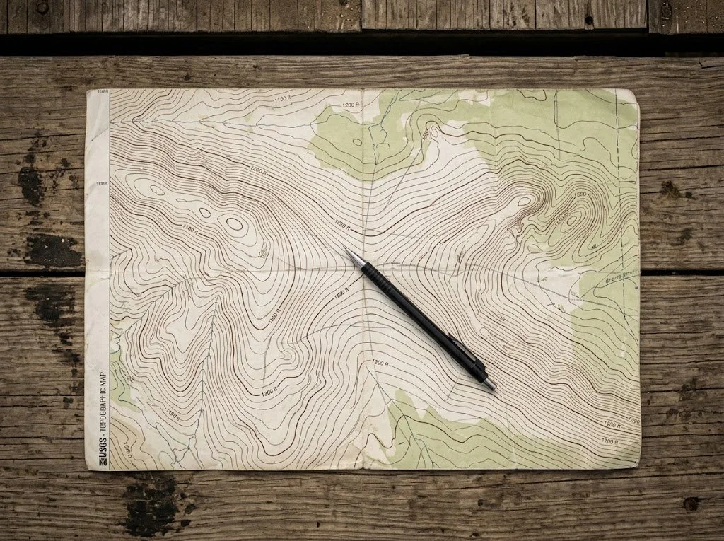
Pull up a USGS 7.5-minute quadrangle for your hunting area. You can download free PDFs at usgs.gov or order a waterproof printed copy. Either way, the map you want shows contour lines at 10, 20, or 40-foot intervals.
Read the contour lines first
Every fifth contour is heavier and labeled with an elevation. Those are index contours. The four lighter lines between each pair of labeled contours are intermediate contours. Find the contour interval listed at the bottom of the map, usually 10, 20, or 40 feet, and you can calculate the exact elevation change anywhere on the sheet.
Where contour lines bunch tightly together, the slope is steep. Where they spread out, the slope is gentle. Memorize that, and half the work is already done.
Look for the hourglass pattern
Run your finger along a ridgeline on the map. You'll see contour lines forming roughly parallel curves along both sides of the ridge. When you find a saddle, those contour lines do something specific. They pinch toward each other from both sides of the ridge at the low point.
If the highest closed contour on the ridge is at 1,200 feet on one side and another closed contour at 1,180 feet sits 200 yards down the spine, the low spot between them is your saddle. The contour lines on the north and south slopes will dip in toward each other at that low point, forming what looks like an hourglass or a bowtie shape.
That bowtie is your visual cue. Once you've seen a few on a map, you'll spot them at a glance.
Estimate the depth and width
Count the contours dropping from each summit down to the saddle low point. If both peaks rise 60 feet above the saddle, that's a real saddle worth investigating. If the drop is only 10 or 15 feet, you're looking at a soft dip in the ridge that may or may not concentrate travel.
For width, measure the gap on the map between where the contour lines on either side of the ridge stop pinching toward each other. A 30-yard saddle is a tight pinch that a deer is almost forced to use. A 200-yard saddle is more of a low, broad pass that animals can scatter across.
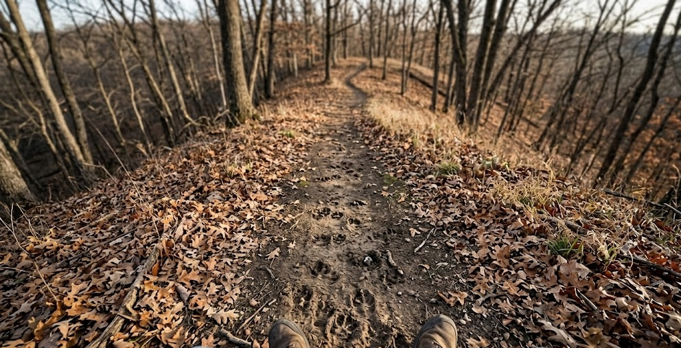
Ground-truthing the saddle on foot
A topo map gives you the candidate. Boots on the ground confirm it. Park where you won't bump deer, walk the ridgeline, and find the actual low point. Sometimes the saddle is exactly where the map said it would be. Other times, a bench or a rock outcrop you couldn't see on the contours shifts the real travel corridor 50 yards left or right.
What you're looking for once you're on the ridge:
Game trails crossing perpendicular to the ridge spine. A worn trail that drops off one side and continues up the other is the saddle's signature.
Tracks and droppings concentrated in the low point.
Rubs and scrapes on both approaches during the fall.
Cover quality. Is the saddle bare, brushy, or thick enough to hold deer?
What's on each side? Bedding cover? An ag field? A creek bottom? The saddle only matters because of what it connects.
If you find a clean trail with sign on both sides and cover that lets a deer slip through without being skylined, you've found a saddle worth hunting. If the spot looks abandoned, move on. Not every saddle on the map gets used.
What separates a great saddle from a marginal one
A few factors decide whether a saddle is a sometimes spot or a year-after-year producer.
Width. A 20 to 40-yard saddle forces deer through a narrow corridor where you can cover the entire crossing with a bow or rifle. A 150-yard saddle gives deer too many options.
Pitch. Steep slopes on either side of the saddle make the low pass even more attractive. Gentle slopes mean deer might just go over the top instead.
Cover. A bare saddle on a hardwood ridge gets used in low light. A brushy saddle with conifer pockets or a creek through it gets used all day.
Connection. A saddle linking two strong bedding areas is dynamite. A saddle linking nothing in particular is a walk-through.
Pressure. A saddle 50 yards off an access road gets hit by every hunter with a phone. A saddle a mile back, on a ridge that requires actual map reading to find, holds deer that haven't been bumped all season. This is where reading terrain without an app earns you real estate other hunters never see.
Setting up to hunt a saddle
Once you've found a good saddle, the wind decides where you sit. Saddles funnel wind the same way they funnel deer. Air moving across a ridge gets compressed through the low point, which means a saddle that runs north-south will push your scent along the trail you're trying to hunt if the wind is wrong.
Set up on the downwind edge of the saddle, 20 to 30 yards back from the main trail crossing. Don't sit dead center in the funnel. You want the wind blowing your scent past the deer's expected approach, not down the corridor they're walking. A crosswind that carries your scent off the ridge entirely is ideal.
For mobile public land setups, a saddle (the terrain feature) is one of the best places to use a saddle (the climbing platform). Yes, the gear shares a name with the terrain. It gets confusing in conversation. The Tethrd Phantom platform lets you hang in any tree, even if the saddle situation gives you no straight branch suitable for a hang-on stand. Check the current price on Amazon.
A pair of decent binoculars helps, too. From the downwind shoulder of the saddle, you can pick apart the approach trails before deer commit to the crossing. The Vortex Diamondback HD 10x42 is the binocular I keep coming back to for this kind of midrange ridgeline work. Check the current price at Amazon. The downside is they're not the lightest pair on the market, so if you're packing miles, the smaller 8x42 model rides easier.
Common mistakes when reading saddles
The biggest mistake new hunters make is calling every dip in a ridge a saddle. A 10-foot bench between two slightly higher points is not a saddle. A saddle is a recognizable terrain feature where two distinct high points flank a clear low point, and the slope drops away on both sides of the ridge. If you can't see the bowtie pattern on the topo, you don't have a saddle. You have a soft spot.
Other mistakes I see regularly:
Hunting the obvious saddle that's 100 yards from the parking lot. That saddle gets sat by a dozen different hunters a season. Look for the harder-to-reach saddles where pressure drops off.
Ignoring saddle width. Hunting a 200-yard saddle is hunting a wide-open field. Find the pinches inside the saddle if it's that broad.
Not checking what's on each side of the ridge. A saddle is only as good as the cover it connects. Walk both sides before you hang a stand.
Setting up in the saddle bottom. Wind compresses there. Sit on the downwind shoulder.
FAQ
How do I know which saddles on a topo map deer actually use?
You don't, until you walk them. The topo identifies candidates. Boots-on-the-ground inspection separates the producers from the dead spots. Look for trail wear, droppings, tracks, and rubs in the low point.
What's the difference between a saddle and a pinch point?
A saddle is a specific type of pinch point defined by elevation. The two high points and the low pass between them create the funnel. A pinch point is broader and encompasses any feature that compresses deer movement, such as creek crossings, fence corners, and brush funnels. Every saddle is a pinch point. Not every pinch point is a saddle.
Can I find saddles using only Google Maps satellite view?
You can identify ridgelines and rough elevation changes on satellite imagery, but you can't read precise contours. A satellite view shows you where the timber is. Topo maps tell you where the terrain forces movement. You need both.
Should I still use a hunting app once I've learned to read terrain?
A mapping app like onX Hunt is useful for verifying property boundaries on public land. The mistake is letting the app replace your eyes and your map skills. Learn the terrain first, then let the app confirm what you already know.
How long does it take to learn to read saddles confidently?
A weekend with a paper topo of the country you know, walking ridgelines and matching map features to what you see on the ground, will get you reading saddles confidently. After that, it's repetition. I still pull up new ground on a paper map before I touch the app.
The takeaway
The hunters who consistently kill mature deer on public land are the ones who can find good ground without depending on a screen. A topo map and a bit of patience will put you on saddles other hunters drive past, because most of them are scrolling instead of reading the country.
Learn the bowtie pattern. Walk the ridges. Confirm the sign. Then, and only then, drop a pin in your app.
Want to find ground like this in your state? Subscribe below for our free state-by-state public land hunting guides, delivered as PDFs you can mark up alongside your topo maps.