How to Find Deer on Public Land: Reading Sign, Terrain, and Pressure to Put Yourself on Deer
Finding deer on public land is a different problem than finding deer on private ground. On a private farm, you know where the food is. You know where the bedding is. You control both, and the deer move between them on a schedule you can pattern over years. On public land, you control nothing. The food sources change. The bedding shifts with pressure. Other hunters alter deer behavior every time they walk into the woods. And you're starting from scratch on ground you've never owned, never managed, and never monitored with cameras year-round.
The hunters who consistently find deer on public land don't rely on luck. They read three things: the terrain tells them where deer want to be, the sign tells them where deer have been, and the pressure tells them where deer are right now. When all three point to the same spot, you've found deer. Here's how to do it.
Step 1: Let the Terrain Tell You Where Deer Want to Be
Before you set foot on a property, the topo map shows you where deer travel, bed, and feed based on the groundis shape. Deer are energy-efficient animals. They take the path of least resistance between bedding and food, they bed where they have a view downhill and an escape route behind them, and they funnel through narrow terrain corridors that squeeze movement into predictable lanes.
On a topo map, these features stand out:
Saddles: Low points on ridgelines where contour lines pinch from both sides. Deer cross ridges at saddles rather than climbing over the highest point.
Benches: Flat shelves on steep slopes where contour lines spread apart on an otherwise steep hillside. Deer bed on benches, especially on the upper third of ridges.
Pinch points: Narrow corridors where steep terrain on one side and water or lowland on the other squeeze walkable ground into a tight lane.
Creek confluences: Where two drainages merge. Trails from separate drainages converge at the junction.
Inside corners: Where a field edge or habitat boundary curves inward creating a concave pocket. Deer traveling along edges converge at the inside corner.
Load your target property in a mapping app, toggle the topo layer, and pin every one of these features. Then switch to satellite imagery and verify the cover. A saddle in thick hardwood is a high-value spot. A saddle in an open hay field is not. The topo tells you where deer should travel. The satellite confirms whether the habitat supports it. [TODO LINK: how to read a topo map for deer hunting -> /field-notes/how-to-read-a-topo-map-for-deer-hunting]
For a faster version of this process, Hunting Scout builds interactive scouting reports from real USGS terrain data that flag funnels, saddles, and pinch points automatically. Three free reports per month, no credit card required.
Step 2: Let the Sign Tell You Where Deer Have Been
Terrain features show you potential. Sign shows you reality. Every terrain feature you pinned from the topo needs ground-truthing with boots, and the sign you find (or don't find) at each location tells you whether the spot is active.

Sign that matters most
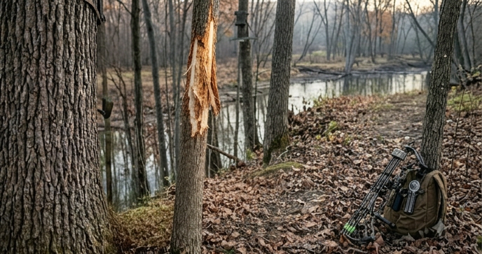
Rub lines. A single rub tells you a buck stood there once. A line of rubs on consecutive trees along a trail tells you a buck travels that route repeatedly. Rub lines are the most reliable indicator of consistent buck travel on public land. Follow them. They connect bedding to food and tell you the exact route a buck takes between the two. Fresh rubs (shaved wood still white, sap still wet) mean recent activity. Old rubs (wood grayed and dried) from last fall still tell you the corridor is established.
Scrapes. A scrape under a licking branch at a trail intersection tells you bucks check that spot during the rut. A line of scrapes along a field edge or creek trail tells you bucks travel that route while making rounds during the pre-rut and rut. The biggest scrapes don't always indicate the biggest bucks. Multiple bucks work the same scrapes. What matters is the scrape's location relative to bedding and food, because that tells you when bucks visit.
Beds. Oval depressions in the leaves or grass, roughly 3 feet long, pressed down with deer hair visible. Finding beds tells you where deer sleep, which is the most valuable information you can gather on public land because bedding locations anchor everything else. Deer travel from bedding to food and back. If you know where the bed is, you know where the trails lead and which direction the deer are coming from.
Tracks in soft ground. Creek crossings, mud bars, field edges after rain, and sandy trails all hold tracks that tell you how many deer are using a spot and which direction they travel. Tracks are freshest in the morning before other animals (and hunters) walk through. A creek crossing with fresh tracks from multiple deer traveling the same direction gives you a travel corridor with a timestamp.
Sign that matters less than people think
Droppings tell you a deer was there. They don't tell you when, how often, or what direction it traveled. A pile of droppings in the middle of a bedding area confirms the bed is active. A random pile on a random trail doesn't tell you much. Don't base your hunt plan on droppings alone.
Browse lines (chewed vegetation at deer height) tell you deer feed in an area. On public land, that's useful for confirming a food source but doesn't give you travel route or timing information the way rubs and scrapes do.
Step 3: Let the Pressure Tell You Where Deer Are Right Now
This is the piece that most public-land hunters miss. Terrain tells you where deer want to be in a vacuum. Sign tells you where they've been. Pressure tells you where they've moved to because of other hunters.
On any public tract, the first wave of hunting pressure pushes deer off their summer and early-fall patterns. The easy-access ridges, the obvious field edges, and the well-worn trails near parking lots get walked through by the Saturday crowd, and the deer adjust. By the second week of archery season, and by the second day of gun season, pressured deer have relocated to the thick, steep, hard-to-reach terrain that other hunters won't fight through.
You find pressured deer by working backward from where the hunters go. Map every parking area, trail, and road access on the property. Draw a half-mile buffer around each one. Everything inside that buffer is the pressure zone. The terrain features that sit outside every pressure zone, the saddles and benches that require a mile-plus walk, a creek crossing, or a steep climb, are where pressured deer stack up after the first wave of orange coats hits the woods.
On a State Game Area I hunt in Michigan, I mapped seven parking lots and the trails from each one. The coverage pattern showed a dead zone: a 400-acre block of steep, laurel-covered terrain more than a mile from any access point. That block held the highest concentration of rubs I found anywhere on the property, and the deer there moved during daylight because they hadn't been disturbed. The terrain that kept other hunters out was the same terrain that made deer feel safe.
Step 4: Connect Bedding to Food
Once you've identified where deer bed and where they feed, the hunt plan writes itself. Deer travel between bedding and food on predictable routes. Your job is to intercept that travel, not to sit in the bedding (you'll blow them out) and not to sit in the food source (mature bucks arrive after dark).
The staging area between bedding and food is where mature public land bucks spend the last 30 minutes of daylight. It's the transition zone where they pause, check the wind, and wait for enough darkness to feel safe moving to the open food source. On a topo, the staging area sits between the dense cover, where contour lines indicate bedding terrain, and the flatter ground or field edge, where the food is.
Set up between the bedding and the staging area, closer to the bedding than the food, on a wind that carries your scent away from both. You're hunting the travel corridor, not the destination. The deer pass you on their way to staging, which means they arrive during daylight. Glass the corridor with Vortex Diamondback HD 10x42 binoculars to verify deer movement before committing to a stand location.

Step 5: Use Cameras to Confirm, Not to Search
Trail cameras on public land are a confirmation tool, not a search tool. Don't hang cameras randomly hoping to find deer. Use the terrain, sign, and pressure analysis to identify the two or three highest-probability spots, then place a Muddy Matrix 2.0 cellular camera at each one to confirm the timing and direction of deer movement.
A cellular camera at a creek crossing you identified through topo analysis and verified with boot-scout sign gives you specific data: which direction the deer come from, what time they arrive, and how many are using the crossing. That data turns a good guess into a hunt plan. Mount cameras high (7 to 8 feet), face north, and never walk to them until you're ready to hunt.
Step 6: Read Deer Behavior in Real Time
Finding deer on public land doesn't stop when you sit down. The hunt itself is a scouting session. Every sit teaches you something if you pay attention.
Which direction deer approach from. If a doe and fawn enter your area from the northeast at 5:15 PM, a buck following the same bedding-to-food pattern will come from the same direction. Adjust your setup on the next sit to face the approach.
What time movement starts. If deer consistently show up at 5:30 PM, don't climb in at 4:00 PM and sit for 90 extra minutes. The extra time in the tree adds scent to the area. Get in at 4:45 and let the tree cool down before deer arrive.
How deer respond to other hunters. If you hear another hunter walking through the property and 20 minutes later a deer runs past you from that direction, you've just learned where pressured deer go when they're pushed. That escape route is where you set up on the next high-pressure day.
Every sit that doesn't produce a shot still produces information. Log what you see, when you see it, and which direction deer move. After three or four sits, you'll have a pattern that no amount of e-scouting can give you.
The Simple Framework
Finding deer on public land comes down to layering three questions:
Where does the terrain tell me deer want to travel and bed? (Topo map, satellite imagery, Hunting Scout reports)
Where does the sign tell me deer have been? (Rubs, scrapes, beds, tracks during off-season boot scouting)
Where does the pressure tell me the deer are right now? (Pressure mapping, access-point buffers, terrain difficulty)
When all three answers point to the same spot, sit there. When they don't, prioritize the pressure answer. Pressured deer don't live where they want to live. They live where other hunters let them live. Find those spots and you find deer. [TODO LINK: public land deer hunting tips -> /field-notes/public-land-deer-hunting-tips]
For a professional-grade look at how terrain, cover, and pressure interact on a specific property, ScoutFlight Hunting Assessments delivers drone-based property reports that give you the aerial perspective boots on the ground can't provide.
Frequently Asked Questions
How do you find deer on public land you've never hunted?
Start with e-scouting. Load the property in a mapping app, read the topo for terrain features (saddles, benches, pinch points), verify cover on satellite imagery, and map the access points to identify pressure zones. Then walk your top 8 to 10 pins during the off-season and check for sign. Cut the list to 3 or 4 confirmed spots and hunt them based on wind direction. The process works on any public tract in any state.

What is the best sign to look for when finding deer on public land?
Rub lines. A line of rubs on consecutive trees along a trail is the most reliable indicator of consistent buck travel. Rub lines connect bedding to food on a predictable route, and they tell you which direction the buck travels (rubs face the direction the buck is heading). Scrapes at trail intersections are the second-best sign for confirming rut-phase buck activity. Beds in thick cover confirm bedding locations and anchor everything else.
How far from the parking lot should you go on public land?
At a minimum of a half mile. On most public tracts, pressure drops off dramatically beyond the first half-mile from any parking area or trail access. For the best results on pressured ground, push past the mile mark. Cross a creek, climb a steep ridge, or wade through thick cover that other hunters avoid. The deer that live past the pressure zone move more naturally during daylight and see fewer hunters across the season.
How do you find deer on flat public land with no terrain features?
On flat ground (Midwest farm country, southern coastal plain, Great Plains), switch your focus from terrain features to habitat features. Look for cover transitions on satellite imagery: timber-to-field edges, inside corners where field meets timber, creek corridors through open country, and isolated cover pockets in large agricultural areas. Pinch points on flat ground come from habitat (a narrow strip of timber connecting two larger woodlots) rather than terrain (a saddle or bench). The sign-reading and pressure-mapping process is the same.
When is the best time to find deer on public land?
The first two weeks of November during archery season. The rut drives mature buck movement during daylight, and the archery crowd is a fraction of the gun-season pressure. For scouting (finding where deer are without hunting them), late February through April is the best window because leaves are down, snow reveals trails and beds, and last fall's rub lines and scrape craters are still visible.
Want more strategies for finding and hunting deer on public land? Subscribe to the LandsToHunt newsletter below and get free state-by-state guides, scouting systems, and seasonal tactics delivered to your inbox.
This article contains affiliate links. LandsToHunt.com earns a small commission on qualifying purchases at no extra cost to you.